


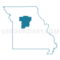
Pettis, Randolph, Saline, Cooper, Howard, Carroll & Chariton Counties PUMA, Missouri
About
Outline

Summary
| Unique Area Identifier | 193277 |
| Name | Pettis, Randolph, Saline, Cooper, Howard, Carroll & Chariton Counties PUMA |
| State | Missouri |
| Area (square miles) | 4,449.88 |
| Land Area (square miles) | 4,394.83 |
| Water Area (square miles) | 55.05 |
| % of Land Area | 98.76 |
| % of Water Area | 1.24 |
| Latitude of the Internal Point | 39.18009450 |
| Longtitude of the Internal Point | -93.03089140 |
Maps

Graphs
Select a template below for downloading or customizing gragh for Pettis, Randolph, Saline, Cooper, Howard, Carroll & Chariton Counties PUMA, Missouri


Neighbors
Neighoring Public Use Microdata Area (by Name) Neighboring Public Use Microdata Area on the Map
- Boone County PUMA, MO
- Cole, Callaway, Moniteau & Osage Counties PUMA, MO
- Johnson, Lafayette, Ray, Clinton & Caldwell Counties PUMA, MO
- Laclede, Polk, Benton, Dallas & Hickory Counties PUMA, MO
- Lawrence, Henry, Vernon, Cedar, Barton, St. Clair & Dade Counties PUMA, MO
- Lincoln, Warren, Audrain, Pike & Montgomery Counties PUMA, MO
- Northeast Missouri PUMA, MO
- Northwest Missouri PUMA, MO
- Pulaski, Camden, Miller & Morgan Counties PUMA, MO
Top 10 Neighboring County (by Population) Neighboring County on the Map
- Boone County, MO (162,642)
- Johnson County, MO (52,595)
- Pettis County, MO (42,201)
- Lafayette County, MO (33,381)
- Audrain County, MO (25,529)
- Randolph County, MO (25,414)
- Ray County, MO (23,494)
- Saline County, MO (23,370)
- Henry County, MO (22,272)
- Morgan County, MO (20,565)
Top 10 Neighboring County Subdivision (by Population) Neighboring County Subdivision on the Map
- Sedalia township, Pettis County, MO (25,331)
- Marshall township, Saline County, MO (14,595)
- Boonville township, Cooper County, MO (10,371)
- South Sugar Creek township, Randolph County, MO (7,499)
- Washington township, Johnson County, MO (7,249)
- Walker township, Moniteau County, MO (6,992)
- North Sugar Creek township, Randolph County, MO (5,994)
- Lexington township, Lafayette County, MO (5,872)
- Brookfield township, Linn County, MO (5,208)
- Davis township, Lafayette County, MO (4,826)
Top 10 Neighboring Place (by Population) Neighboring Place on the Map
- Sedalia city, MO (21,387)
- Moberly city, MO (13,974)
- Marshall city, MO (13,065)
- Boonville city, MO (8,319)
- Carrollton city, MO (3,784)
- Windsor city, MO (2,901)
- Fayette city, MO (2,688)
- Marceline city, MO (2,233)
- Slater city, MO (1,856)
- Salisbury city, MO (1,618)
Top 10 Neighboring Elementary School District (by Population) Neighboring Elementary School District on the Map
- Renick R-V School District, MO (1,210)
- Pettis County R-XII School District, MO (1,044)
- Blackwater R-II School District, MO (913)
- Clarksburg C-2 School District, MO (805)
- Middle Grove C-1 School District, MO (691)
- Callao C-8 School District, MO (645)
- Hardeman R-X School District, MO (578)
- Miami R-I School District, MO (569)
- Orearville R-IV School District, MO (400)
- Gilliam C-4 School District, MO (351)
Top 10 Neighboring Unified School District (by Population) Neighboring Unified School District on the Map
- Columbia Public Schools, MO (136,836)
- Sedalia 200 School District, MO (29,793)
- Moberly School District, MO (16,390)
- Marshall School District, MO (15,199)
- Boonville School District, MO (11,591)
- Macon County R-I School District, MO (8,696)
- Knob Noster R-VIII School District, MO (8,419)
- Moniteau County R-I School District, MO (7,210)
- Brookfield R-III School District, MO (6,503)
- Lexington R-V School District, MO (5,908)
Top 10 Neighboring State Legislative District Lower Chamber (by Population) Neighboring State Legislative District Lower Chamber on the Map
- State House District 24, MO (46,896)
- State House District 122, MO (40,384)
- State House District 116, MO (38,212)
- State House District 121, MO (37,199)
- State House District 9, MO (36,616)
- State House District 118, MO (36,454)
- State House District 36, MO (35,669)
- State House District 117, MO (35,534)
- State House District 120, MO (35,276)
- State House District 7, MO (34,548)
Top 10 Neighboring State Legislative District Upper Chamber (by Population) Neighboring State Legislative District Upper Chamber on the Map
- State Senate District 31, MO (190,281)
- State Senate District 19, MO (188,056)
- State Senate District 6, MO (181,242)
- State Senate District 28, MO (177,259)
- State Senate District 12, MO (169,332)
- State Senate District 21, MO (163,305)
- State Senate District 18, MO (159,547)
Top 10 Neighboring 111th Congressional District (by Population) Neighboring 111th Congressional District on the Map
- Congressional District 6, MO (693,974)
- Congressional District 9, MO (684,101)
- Congressional District 4, MO (679,375)
Top 10 Neighboring Census Tract (by Population) Neighboring Census Tract on the Map
- Census Tract 18.05, Boone County, MO (9,020)
- Census Tract 9601, Johnson County, MO (8,677)
- Census Tract 19.02, Boone County, MO (8,249)
- Census Tract 904, Lafayette County, MO (6,794)
- Census Tract 4701, Morgan County, MO (6,046)
- Census Tract 9607, Johnson County, MO (5,908)
- Census Tract 4802, Pettis County, MO (5,867)
- Census Tract 902, Lafayette County, MO (5,829)
- Census Tract 4906, Randolph County, MO (5,698)
- Census Tract 9609, Johnson County, MO (4,939)
Top 10 Neighboring 5-Digit ZIP Code Tabulation Area (by Population) Neighboring 5-Digit ZIP Code Tabulation Area on the Map
- 65301, MO (34,267)
- 65270, MO (17,681)
- 65340, MO (15,937)
- 64601, MO (12,438)
- 65233, MO (11,703)
- 65018, MO (7,714)
- 64628, MO (6,144)
- 65336, MO (5,981)
- 64067, MO (5,789)
- 64633, MO (5,216)